Amt Warburg-Land: Difference between revisions
Jump to navigation
Jump to search
Knorrepoes (talk | contribs) No edit summary |
Knorrepoes (talk | contribs) m (Text replace - "|width="15%"|50 px|right |} " to "|width="15%"|50 px|right |}<seo title="Wappen, Gemeindewappen" /> ") |
||
| Line 3: | Line 3: | ||
|width="70%" align="center" |'''Heraldry of the World<br/>Civic heraldry of [[Germany]] - [[Deutsche Wappen|Deutsche Wappen (Gemeindewappen/Kreiswappen)]]''' | |width="70%" align="center" |'''Heraldry of the World<br/>Civic heraldry of [[Germany]] - [[Deutsche Wappen|Deutsche Wappen (Gemeindewappen/Kreiswappen)]]''' | ||
|width="15%"|[[File:Germany.jpg|50 px|right]] | |width="15%"|[[File:Germany.jpg|50 px|right]] | ||
|} | |}<seo title="Wappen, Gemeindewappen" /> | ||
'''AMT WARBURG-LAND ''' | '''AMT WARBURG-LAND ''' | ||
Revision as of 19:12, 5 November 2012
 |
Heraldry of the World Civic heraldry of Germany - Deutsche Wappen (Gemeindewappen/Kreiswappen) |
|
AMT WARBURG-LAND
State : Nordrhein-Westfalen
District (Kreis) : Warburg
Incorporated into : 1975 Warburg

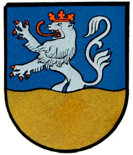
Origin/meaning
The arms were officially granted on October 19, 1938.
The arms show in the upper part the arms of the Counts von Everstein, who in medieval times ruled the area from their estate on the Koglenberg. The base shows the rich farmlands around the Diemel river.
To the Amt belonged:
- Bonenburg
- Calenberg
- Dalheim
- Dössel
- Germete
- Herlinghausen
- Hohenwepel
- Menne
- Nörde
- Ossendorf
- Rimbeck
- Scherfede
- Welda
- Wormeln
Literature : Meyer, 1940