Blåvandshuk: Difference between revisions
Jump to navigation
Jump to search
Knorrepoes (talk | contribs) m (Text replacement - "{{dk}}↵↵'''" to "'''") |
Knorrepoes (talk | contribs) m (Text replacement - "{{media}}" to "") |
||
| Line 13: | Line 13: | ||
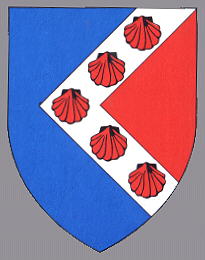
The arms are in a way canting, the name means Blue-water-point, and the municipality is situated on the Westernmost part of Denmark. The arms thus show the red land pointing into the blue sea. The red colour for the land is taken from the colour of the berries that used to be very abundant in the area. The silver chevron with the shells symbolises the famous beaches in the municipality. | The arms are in a way canting, the name means Blue-water-point, and the municipality is situated on the Westernmost part of Denmark. The arms thus show the red land pointing into the blue sea. The red colour for the land is taken from the colour of the berries that used to be very abundant in the area. The silver chevron with the shells symbolises the famous beaches in the municipality. | ||
[[Literature]]: Achen, 1982; Zeuthen, 2000 | [[Literature]]: Achen, 1982; Zeuthen, 2000 | ||
Revision as of 06:46, 1 July 2023
BLÅVANDSHUK
Region : Midtjylland
Amt (until 2007) : Ribe
Additions : 1970 Ho-Oksby, Ål
Incorporated into : 2007 Varde

Origin/meaning
The arms were officially granted in 1972.
The arms are in a way canting, the name means Blue-water-point, and the municipality is situated on the Westernmost part of Denmark. The arms thus show the red land pointing into the blue sea. The red colour for the land is taken from the colour of the berries that used to be very abundant in the area. The silver chevron with the shells symbolises the famous beaches in the municipality.
Literature: Achen, 1982; Zeuthen, 2000