Nes (Buskerud): Difference between revisions
Jump to navigation
Jump to search
Knorrepoes (talk | contribs) No edit summary |
Knorrepoes (talk | contribs) m (Text replace - "[[Literature" to "{{media}} [[Literature") |
||
| Line 18: | Line 18: | ||
Nes, or peninsula, is situated on the flat area where two rivers meet (Rukkedøla and Hallingdalselv). This geographical situation is symbolised by the gold (sandy) point. | Nes, or peninsula, is situated on the flat area where two rivers meet (Rukkedøla and Hallingdalselv). This geographical situation is symbolised by the gold (sandy) point. | ||
{{media}} | |||
[[Literature]] : [http://www.kf.kommorg.no/ Norwegian Municipal Network] and Norske Kommunevåpen, Kommunalforlaget, 1987. | [[Literature]] : [http://www.kf.kommorg.no/ Norwegian Municipal Network] and Norske Kommunevåpen, Kommunalforlaget, 1987. | ||
Revision as of 02:08, 9 July 2014
 |
Heraldry of the World Civic heraldry of Norway - Norske Kommunevåpen |
|
NES
Province : Buskerud

Official blazon
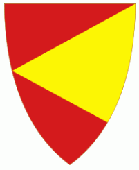
På rød bunn en liggende gull spiss vendt mot heraldisk høyre.
Origin/meaning
The arms were granted on June 29, 1979.
Nes, or peninsula, is situated on the flat area where two rivers meet (Rukkedøla and Hallingdalselv). This geographical situation is symbolised by the gold (sandy) point.
Contact and Support


Partners:


Your logo here ?
Contact us
© since 1995, Heraldry of the World, Ralf Hartemink 
Index of the site
Literature : Norwegian Municipal Network and Norske Kommunevåpen, Kommunalforlaget, 1987.