Odsherred: Difference between revisions
Jump to navigation
Jump to search
Knorrepoes (talk | contribs) m (Text replacement - "Literature :" to "Literature:") |
Knorrepoes (talk | contribs) m (Text replacement - "{{media}} Literature: [[" to "Literature: {{media}} [[") |
||
| Line 13: | Line 13: | ||
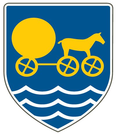
The arms are mainly based on the arms of Trundholm, and show a cart based on a prehistoric find in the municipality. The waves indicate the three former municipalities and the geographical position of the municipality, which is surrounded by the sea on three sides. | The arms are mainly based on the arms of Trundholm, and show a cart based on a prehistoric find in the municipality. The waves indicate the three former municipalities and the geographical position of the municipality, which is surrounded by the sea on three sides. | ||
[[Literature]]: | |||
{{media}} | {{media}} | ||
[[Category:Danish municipalities]] | [[Category:Danish municipalities]] | ||
[[Category:Granted 2007]] | [[Category:Granted 2007]] | ||
Revision as of 08:03, 9 September 2022
Denmark heraldry portal
This page is part of the  |
 |
|
Danish heraldry:
|

 |
ODSHERRED
Region : Sjælland
Amt (until 2007) : Vestsjælland (until 1970 Holbæk)
Additions : 2007 Dragsholm (1970 Asnæs, Fårevejle, Grevinge, Vallekilde-Hørve), Nykøbing-Rørvig (1970 Nykøbing (Sjælland), Rørvig), Trundholm (1970 Egebjerg, Højby, Nørre Asmindrup, Odden, Vig)

Origin/meaning
The arms were officially registered in 2007.
The arms are mainly based on the arms of Trundholm, and show a cart based on a prehistoric find in the municipality. The waves indicate the three former municipalities and the geographical position of the municipality, which is surrounded by the sea on three sides.
Contact and Support


Partners:


Your logo here ?
Contact us
© since 1995, Heraldry of the World, Ralf Hartemink 
Index of the site