Jamaica (parish): Difference between revisions
Knorrepoes (talk | contribs) No edit summary |
Knorrepoes (talk | contribs) m (Text replacement - "{|width="100%" style="color:black; background-color:#ffffcc;" |width="15%"|50 px|left |width="70%" align="center" |'''Heraldry of the World<br>Civic heraldry of Cuba''' |width="15%"|[[File:Cuba.jpg|50 px|right]...) Tags: Mobile edit Mobile web edit |
||
| (7 intermediate revisions by the same user not shown) | |||
| Line 1: | Line 1: | ||
{ | {{cu}} | ||
'''JAMAICA''' | '''JAMAICA''' | ||
| Line 10: | Line 6: | ||
Municipality : [[San Jose de Las Lajas]] | Municipality : [[San Jose de Las Lajas]] | ||
[[File:jamaica-cuba.jpg|center]] | [[File:jamaica-cuba.jpg|center|Arms (crest) of {{PAGENAME}}]] | ||
===Official blazon=== | |||
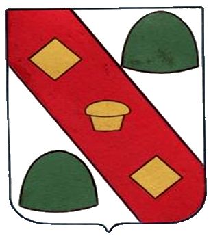
En campo de plata una banda de gules como pieza honorable, cargada de un panqué de oro en su centro o abismo del escudo y entre dos losanges de oro. Le acompañan dos montes de sinople, a cada lado. | En campo de plata una banda de gules como pieza honorable, cargada de un panqué de oro en su centro o abismo del escudo y entre dos losanges de oro. Le acompañan dos montes de sinople, a cada lado. | ||
===Origin/meaning=== | |||
The bend refers to the Cuban Central Road that runs through the parish. The road was initially built in the early 19th century, paved in 1852, and is one of the principal roads in the country. The road was of strategic importance during the War of Independence of Cuba and the red colour refers to the battels to control the road. | The bend refers to the Cuban Central Road that runs through the parish. The road was initially built in the early 19th century, paved in 1852, and is one of the principal roads in the country. The road was of strategic importance during the War of Independence of Cuba and the red colour refers to the battels to control the road. | ||
| Line 22: | Line 18: | ||
The image in the centre refers to the famous local Jamaica pancakes, the diamonds to the tile and bathroom fixtures factories in the parish. | The image in the centre refers to the famous local Jamaica pancakes, the diamonds to the tile and bathroom fixtures factories in the parish. | ||
{{media}} | |||
[[Literature]] : Image obtained by Carlos López | [[Literature]] : Image obtained by Carlos López | ||
[[Category:Parishes of Cuba]] | [[Category:Parishes of Cuba]] | ||
[[Category:Mayabeque]] | [[Category:Mayabeque]] | ||
Latest revision as of 09:58, 26 June 2021
| Heraldry of the World Heráldica del mundo |
| Cuban heraldry portal Heráldica cubana |
|
JAMAICA
Province : Mayabeque
Municipality : San Jose de Las Lajas
Official blazon
En campo de plata una banda de gules como pieza honorable, cargada de un panqué de oro en su centro o abismo del escudo y entre dos losanges de oro. Le acompañan dos montes de sinople, a cada lado.
Origin/meaning
The bend refers to the Cuban Central Road that runs through the parish. The road was initially built in the early 19th century, paved in 1852, and is one of the principal roads in the country. The road was of strategic importance during the War of Independence of Cuba and the red colour refers to the battels to control the road.
The two green hills are the Camoa and Somorrostro hills on the entrance to the valley of San Jose de las Lajas. They also refer to the stone quarries in the parish.
The image in the centre refers to the famous local Jamaica pancakes, the diamonds to the tile and bathroom fixtures factories in the parish.
Contact and Support
Partners:
Your logo here ?
Contact us
© since 1995, Heraldry of the World, Ralf Hartemink 
Index of the site
Literature : Image obtained by Carlos López


