Skalnaté Pleso: Difference between revisions
Jump to navigation
Jump to search
Knorrepoes (talk | contribs) m (Text replace - "{|width="100%" style="color:black; background-color:#ffffcc;" |width="15%"|50 px|left |width="70%" align="center" |'''Heraldry of the World<br/>Civic heraldry of Slovakia (Erby slovenských miest)''' |width="15%"|) |
Knorrepoes (talk | contribs) m (Text replacement - "|center]] ====Official blazon====" to "|center|{{PAGENAME}} (Erb, znak)]] ====Official blazon====") |
||
| Line 7: | Line 7: | ||
Municipality : [[Vysoké Tatry]] | Municipality : [[Vysoké Tatry]] | ||
[[File:skalnate.jpg|center]] | [[File:skalnate.jpg|center|{{PAGENAME}} (Erb, znak)]] | ||
====Official blazon==== | ====Official blazon==== | ||
Revision as of 08:40, 27 January 2016
SKALNATÉ PLESO MOUNTAIN HUT
Province : Prešov
District (okres) : Poprad
Municipality : Vysoké Tatry
Official blazon
Origin/meaning
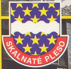
At the Skalnaté Pleso lake and on Lomický Štit above the lake, there are meteorology and astronomy observation institutes, which is symbolised by the stars in the arms. The blue field and the silver bend symbolise the lake and the rivers near the hut.
Contact and Support
Partners:
Your logo here ?
Contact us
© since 1995, Heraldry of the World, Ralf Hartemink 
Index of the site
Literature : Alexy, 1988


