Czechoslovakia: Difference between revisions
Jump to navigation
Jump to search
Czechoslovakia - Československo / Česko‑Slovensko
Knorrepoes (talk | contribs) No edit summary |
Knorrepoes (talk | contribs) m (Text replacement - "*[[" to "* [[") |
||
| Line 31: | Line 31: | ||
==Heraldic collector's items== | ==Heraldic collector's items== | ||
*[[File:front.red.jpg|75 px]][[Redua]] : Sbírka znaků měst Republiky Československé | * [[File:front.red.jpg|75 px]][[Redua]] : Sbírka znaků měst Republiky Československé | ||
*[[File:hag-cs1.jpg|75 px]][[Znaky Republiky Československé]] | * [[File:hag-cs1.jpg|75 px]][[Znaky Republiky Československé]] | ||
*[[File:Cs-1820.jpg|75 px]][[Czechoslovakia (stamps)|Heraldic stamps]] from Czechoslovakia | * [[File:Cs-1820.jpg|75 px]][[Czechoslovakia (stamps)|Heraldic stamps]] from Czechoslovakia | ||
[[Category:Czechoslovakia]] | [[Category:Czechoslovakia]] | ||
[[Category:Europe]] | [[Category:Europe]] | ||
Revision as of 20:24, 26 June 2017
| Heraldry of the World The main resource for civic heraldry since 1996 with 294,966 images |

|

|

|
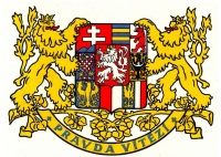
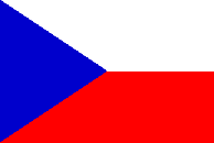
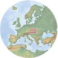
| The National arms of Czechoslovakia | The National Flag | Location |
Administrative division
Czechoslovakia was a state comprising current Czech Republic and Slovakia.
The administrative division was complicated :
- 1918–1923: Different systems in former Austrian territory (Bohemia, Moravia, a small part of Silesia) compared to former Hungarian territory (Slovakia and Ruthenia): three lands (země) (also called district units (obvody)): Bohemia, Moravia, Silesia, plus 21 counties (župy) in today's Slovakia and three counties in today's Ruthenia; both lands and counties were divided into districts (okresy).
- 1923–1927: As above, except that the Slovak and Ruthenian counties were replaced by six (grand) counties ((veľ)župy) in Slovakia and one (grand) county in Ruthenia, and the numbers and boundaries of the okresy were changed in those two territories.
- 1928–1938: Four lands (Czech: země, Slovak: krajiny): Bohemia, Moravia-Silesia, Slovakia and Subcarpathian Ruthenia, divided into districts (okresy).
- Late 1938 – March 1939: As above, but Slovakia and Ruthenia gained the status of "autonomous lands".
- 1945–1948: As in 1928–1938, except that Ruthenia became part of the Soviet Union.
- 1949–1960: 19 regions (kraje) divided into 270 okresy.
- 1960–1992: 10 kraje, Prague, and (from 1970) Bratislava (capital of Slovakia); these were divided into 109–114 okresy; the kraje were abolished temporarily in Slovakia in 1969–1970 and for many purposes from 1991 in Czechoslovakia; in addition, the Czech Socialist Republic and the Slovak Socialist Republic were established in 1969 (without the word Socialist from 1990).
Heraldry
All cities used arms, see under Czech Republic and Slovakia.
Heraldic collector's items
 Redua : Sbírka znaků měst Republiky Československé
 Znaky Republiky Československé
 Heraldic stamps from Czechoslovakia
