Ngaruawahia
| Heraldry of the World Civic heraldry of New Zealand |
NGARUAWAHIA
Region: Waikato
District : Waikato
Incorporated into : 1989 Waikato District
Official blazon
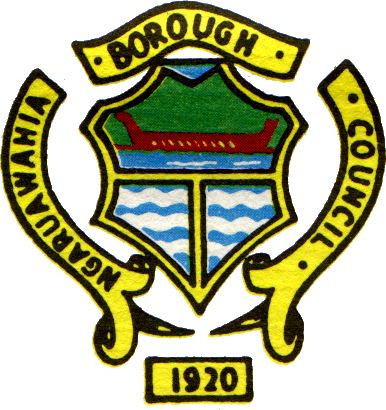
===Origin/meaning===Ngaruawahia is located at the junction of two significant rivers, the Waikato and the Waipa, which is denoted by the bottom portion of the shield of its Crest being divided to signify the two rivers meeting.
The green background to the top half of the shield is to signify the bush covered Hakarimata ranges (mountains) which form the backdrop to the Town and the canoe on the river is a Maori war canoe to illustrate the fact that the first occupants of the area were Maori. Being at the confluence of the two rivers, Ngaruawahia was a stepping stone to the rest of the fertile river plains further inland and therefore has a very long history in terms of the settlement of New Zealand.
It also has a significant Maori history in that it is the headquarters of the Maori King movement and has been for as long as the history of the area has been recorded. The Maori Queen Te Ariki Dame Te Ata Irangi Kaahu, has her official residence at the Turangawaewae Marae in Ngaruawahia. Turangawaewae means literally "a place to stand" and a marae is a gathering place, or what you might call a village common, on which a meeting house is usually placed. Ngaruawahia was also the location of a major camp for British Troops during the Maori Land Wars.
Contact and Support
Partners:
Your logo here ?
Contact us
© since 1995, Heraldry of the World, Ralf Hartemink 
Index of the site
Literature : Information obtained from Lawrence Jones


