Hesel: Difference between revisions
Jump to navigation
Jump to search
Knorrepoes (talk | contribs) No edit summary |
Knorrepoes (talk | contribs) m (Text replace - "[[Literature" to "{{media}} [[Literature") |
||
| Line 17: | Line 17: | ||
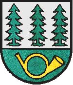
The largest forest in Ostfriesland and the Leer district, the Heseler Wald, is situated in the municipality, which is symbolised by the pine trees. Hesel is situated on a junction of several historical postal routes, one from Aurich to Leer, the other from Bremen to Holland. A large postal station thus existed in the village, which is symbolised by the post horn in the arms. | The largest forest in Ostfriesland and the Leer district, the Heseler Wald, is situated in the municipality, which is symbolised by the pine trees. Hesel is situated on a junction of several historical postal routes, one from Aurich to Leer, the other from Bremen to Holland. A large postal station thus existed in the village, which is symbolised by the post horn in the arms. | ||
{{media}} | |||
[[Literature]] : Image and information provided by the Samtgemeinde Hesel. | [[Literature]] : Image and information provided by the Samtgemeinde Hesel. | ||
Revision as of 22:50, 8 July 2014
 |
Heraldry of the World Civic heraldry of Germany - Deutsche Wappen (Gemeindewappen/Kreiswappen) |
|
HESEL
State : Niedersachsen
District (Kreis) : Leer
Samtgemeinde : Samtgemeinde Hesel

Origin/meaning
The arms were granted on March 12, 1968.
The largest forest in Ostfriesland and the Leer district, the Heseler Wald, is situated in the municipality, which is symbolised by the pine trees. Hesel is situated on a junction of several historical postal routes, one from Aurich to Leer, the other from Bremen to Holland. A large postal station thus existed in the village, which is symbolised by the post horn in the arms.
Contact and Support


Partners:


Your logo here ?
Contact us
© since 1995, Heraldry of the World, Ralf Hartemink 
Index of the site
Literature : Image and information provided by the Samtgemeinde Hesel.