Miltenberg (kreis): Difference between revisions
Knorrepoes (talk | contribs) m (Text replace - "'''Origin/meaning :'''<br/>" to "====Origin/meaning====") |
Knorrepoes (talk | contribs) m (Text replace - "|width="15%"|50 px|right |} " to "|width="15%"|50 px|right |}<seo title="Wappen, Gemeindewappen" /> ") |
||
| Line 3: | Line 3: | ||
|width="70%" align="center" |'''Heraldry of the World<br/>Civic heraldry of [[Germany]] - [[Deutsche Wappen|Deutsche Wappen (Gemeindewappen/Kreiswappen)]]''' | |width="70%" align="center" |'''Heraldry of the World<br/>Civic heraldry of [[Germany]] - [[Deutsche Wappen|Deutsche Wappen (Gemeindewappen/Kreiswappen)]]''' | ||
|width="15%"|[[File:Germany.jpg|50 px|right]] | |width="15%"|[[File:Germany.jpg|50 px|right]] | ||
|} | |}<seo title="Wappen, Gemeindewappen" /> | ||
'''MILTENBERG (MIL''') | '''MILTENBERG (MIL''') | ||
Revision as of 19:20, 5 November 2012
| Heraldry of the World Civic heraldry of Germany - Deutsche Wappen (Gemeindewappen/Kreiswappen) |
MILTENBERG (MIL)
State : Bayern
Additions : 1972 Obernburg am Main
Origin/meaning
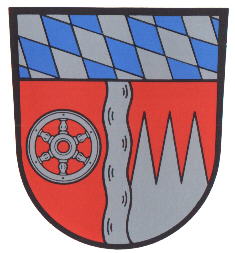
The arms were granted on May 25, 1977.
The wheel is the wheel of the State of Mainz, which was part of the arms of both older districts. The points are the arms of the State of Würzburg, and are here used as the arms for the Franken area. The pale is the Main river and the chief is the arms of Bayern. The area belongs since 1816 to Bayern.
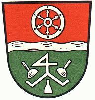
The old arms were granted on October 2nd, 1963.
The arms are a combination of the river Main, the wheel of the arms of Mainz and some tools used in the sandstone quarries. The district is situated alongside the river Main and the main industries are the sandstone quarries, agriculture and forestry. The latter two are symbolised by the green colour in the lower part of the arms. A large part of the district was part of the State of Mainz, namely the former Ämter Miltenberg, Amorbach, Klingenberg and Grossheubach.
Literature : Stadler, 1964-1971, 8 volumes; Linder and Olzog, 1996.


