Esselbach: Difference between revisions
Jump to navigation
Jump to search
Knorrepoes (talk | contribs) m (Text replacement - "↵↵'''" to "'''") Tags: Mobile edit Mobile web edit |
Knorrepoes (talk | contribs) m (Text replacement - "Additions :" to "Additions:") |
||
| Line 3: | Line 3: | ||
State : [[Bayern]]<br/> | State : [[Bayern]]<br/> | ||
District (Kreis) : [[Main-Spessart]] (until 1973 [[Marktheidenfeld (kreis)|Marktheidenfeld]])<br/> | District (Kreis) : [[Main-Spessart]] (until 1973 [[Marktheidenfeld (kreis)|Marktheidenfeld]])<br/> | ||
Additions : 1978 Kredenbach, Steinmark | Additions: 1978 Kredenbach, Steinmark | ||
[[File:Esselbach.jpg|center|alt=Wappen von {{PAGENAME}}/Arms (crest) of {{PAGENAME}}]] | [[File:Esselbach.jpg|center|alt=Wappen von {{PAGENAME}}/Arms (crest) of {{PAGENAME}}]] | ||
Revision as of 10:28, 28 January 2024
ESSELBACH
State : Bayern
District (Kreis) : Main-Spessart (until 1973 Marktheidenfeld)
Additions: 1978 Kredenbach, Steinmark
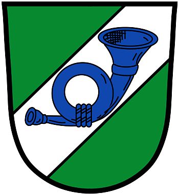
| German | In Grün ein breiter silberner Schräglinksbalken, dem ein schräglinks gestelltes blaues Posthorn aufgelegt ist
Origin/meaningThe arms were officially granted on June 22, 1971. Esselbach is situated on a main road between Würzburg and Frankfurt and had already in the 15th century a postal station founded by the Archbishops of Mainz. The postal station played a major role in the development of the village. The arms thus show the road with a postal horn. The green colour refers to the Spessart nature region.
Contact and SupportPartners: Your logo here ?
© since 1995, Heraldry of the World, Ralf Hartemink Literature: Image and information from the Unterfranken region |


